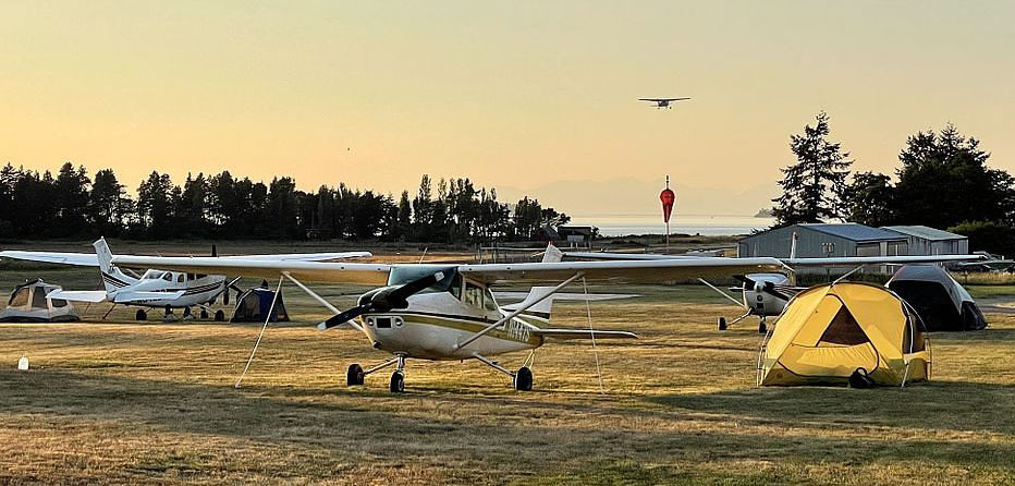
Airplane camping in Washington is a far cry from the meccas of Idaho, Utah, or Alaska. Despite all of the forested and mountainous terrain in Washington there are no true backcountry airports in the state. Nevertheless, there are a healthy amount of fly-in camping options on the more beaten path for pilots to enjoy. The tradeoff for this accessibility being, unlike the aforementioned backcountry playgrounds like Idaho, the best airport campgrounds in Washington don’t require planes capable of 500ft takeoff rolls and tundra tires.
The airports listed here are (arguably) the best camping spots in Washington. They are all public airports and have long and smooth enough runways for those flying trikes to operate from. All the while still being some incredible destinations that make flying GA worth all that time, effort, and money. Although if you’re looking for something marginally more challenging, take a look at my most accessible Idaho backcountry airports list.
First, a word of caution: Some of the airports listed here require mountain flying experience and close attention paid to density altitude on those hot summer days. Without mountain flying instruction you don’t know what you don’t know. Before attempting to land at any mountain airport it’s critical that you know your performance numbers, the weather, your approach, your go-around procedure, and everything/anything else you need for operating in the mountains (which you got formal instruction for, right?). There is no guarantee that you can safely land/takeoff from the airports listed here, that is for you to do more research on and ultimately determine.
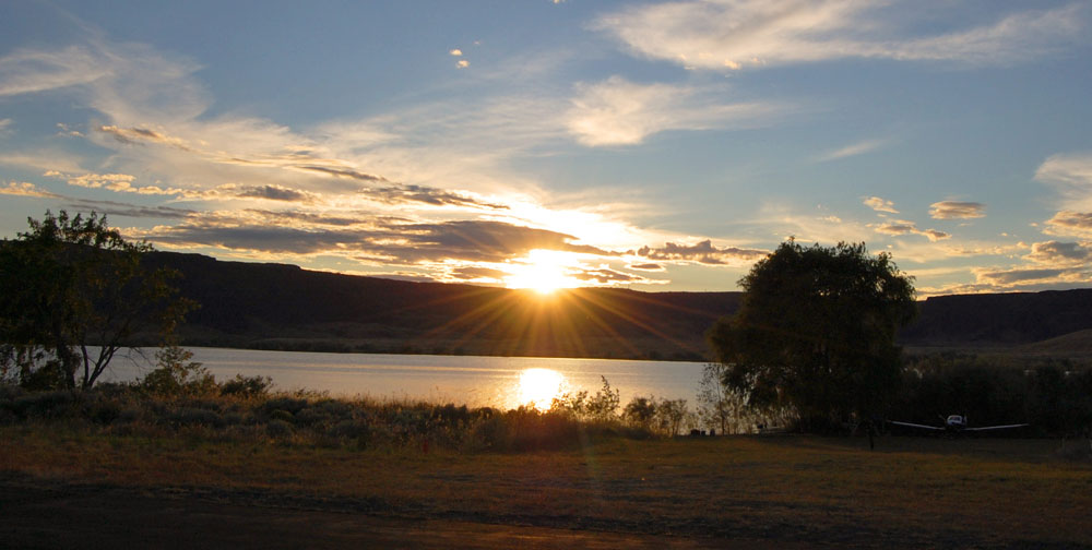
1. 09S - Sullivan Lake State
- Elevation: 2,614ft
- Runway length: 1,765ft
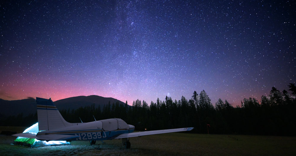
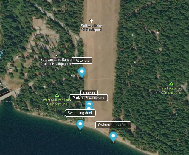
At the top of the list is the eastern-most airport on this list. Located in the northeast corner of Washington within the Colville National Forest sits the Sullivan Lake airport. It is in the middle of a national forest campground and directly abuts its namesake, Sullivan Lake.
The campground itself is quite popular and can be difficult to get a campsite reservation at, but for pilots flying in, camping next to your plane is available all along the western side of the airport fence meaning there is never a shortage of space. The campsites here have a handful of picnic tables and firepits. There are also carts for hauling gear should you decide to get a campsite reservation in the campground. The tradeoff for the flexibility of camping inside the fence is that it provides no tree shade. If that’s desirable then getting a campsite in the campground may be worth it.
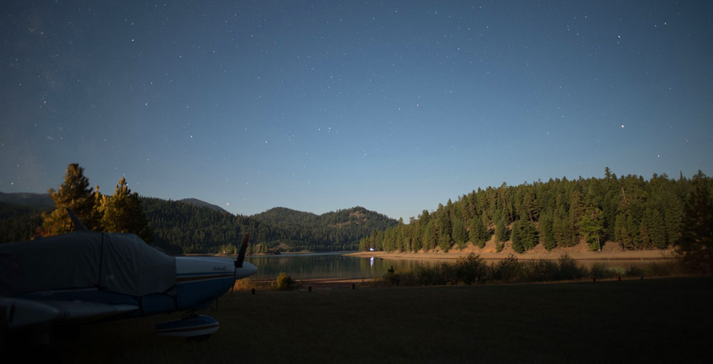
Once on the ground, the main attraction is the lake. Notably, Sullivan Lake is exceptionally warm making it an excellent swimming location. Located on the beach south of the runway is a swimming dock and further to the east is a floating swimming platform. Sometimes there are buoys for tying off a raft to for prolonged lounging in the lake without being pushed back to shore. Aside from swimming, there are a few hiking trails in the area, one along the east shore of the lake. At night, take advantage of the lack of light pollution to enjoy the plethora of stars on a clear night.
Take note though: The runway here is quite short for your average GA plane, especially one loaded down with camping gear and on hot summer days. At just over 1,700ft you’ll need to have your approach dialed in as there is little margin for error. What’s more, the terrain to the north is rising meaning a late go around is likely not possible and has been the source of crashes in the past. Due to this, landing 34 and departing 16 is the strongly preferred option. When departing, the runway abuts the lake so despite the short field there are no obstacles to clear making for much more comfortable takeoffs than other would otherwise be possible with a runway of that length in your standard GA plane.
Also note that despite fencing running along both sides of the runway, its location between two sides of a campground means it gets a large amount of pedestrian traffic. Doing a low pass before landing is highly recommended to scare off any children that found the open ground a good place to play.
For more info and a detailed map of the airport see Sullivan Lake on Pirep.
 Credit: Airport map screenshot from Pirep.io
2. 6S9 - Stehekin State
- Elevation: 1,230ft
- Runway length: 2,630ft
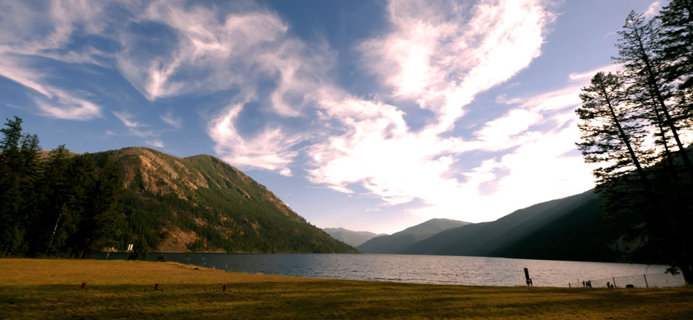
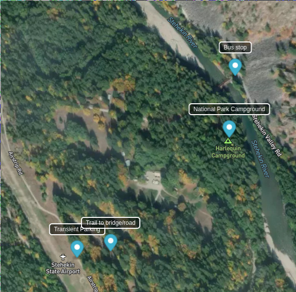
Stehekin State is the closest we have in Washington to a true “backcountry” airport. The town of Stehekin is located on the north end of Lake Chelan with the only access being by boat, plane, or foot via hiking in. Due to this isolation, Stehekin is generally a quiet outpost in the center of the Cascades.
While camping is not available directly at the airport in Stehekin, the Harlequin Campground (part of North Cascades National Park) is located a short walk from the runway, and is along the shore of the Stehekin River making for an picturesque camping location. Note though that reservations for this campground are required through recreation.gov during the summer. There are eight campsites, but one is first come, first serve if you get there early enough to grab it on a given day.
Within the Stehekin valley there are numerous activities. The airport itself is located about three miles from the lake. If you have folding bikes for your plane, this is a great location for them. Alternatively, for a small fee the Stehekin Shuttle runs up and down the valley road multiple times per day during the summer with a stop near the airport at the Harlequin Bridge.
For those not looking for tent camping, there are commercial outfits in the valley such as the Stehekin Valley Ranch with cabins/rooms for rent and prepared meals.
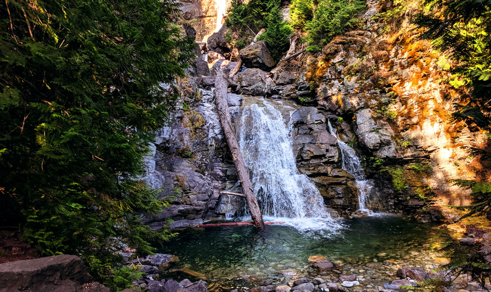
As for day activities, being inside the national park, excellent hiking options are abound. An easy option near(-ish) the airport is Rainbow Falls (pictured above). For getting on the water, kayak rentals are available near the ferry dock as well as are a few swimming areas.
Last, but far from least, visiting Stehekin necessitates a stop at the bakery. Formally called the Stehekin Pastry Company, all sorts of delicious baked goods are available. If there’s one place to stop in Stehekin, this is it.
With regards to flying in/out, while the elevation of the field is fairly low, density altitude problems do exist on hot summer days. This is compounded by large trees on either end of the runway. The runway is sloped upward to the north as well making arriving 31 and departing 13 the preferred direction. The terrain around here is not forgiving with narrow and dead end canyons in nearly every direction other than south along the lake. Ensure you are proficient with canyon flying and know the terrain well.
For more info and a detailed map of the airport see Stehekin State on Pirep.
3. KORS - Eastsound / Orcas Island
- Elevation: 34ft
- Runway length: 2,901ft
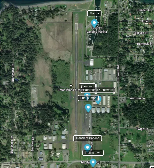
Eastsound on Orcas Island is a favorite past-time of Puget Sound area pilots. Not only does it make a great day trip location due to its proximity to the town of Eastsound with myriad restaurants, shops, and activities, but it is also a favorite camping location due to the on-field camping, aforementioned attractions, and ease of access.
The camping area on the field is located on the east side in the grass area north of the main ramp. To the east near the hangars is a small bathrooms & showers building. As of this writing, the nightly tie-down fee for camping on the field is $20.
What makes Eastsound shine is not necessarily the on-field camping, but the attractions nearby. The town of Eastsound is a 15 minute walk to the south on a dedicated walking path through the woods. From there, numerous breakfast, lunch, and dinner restaurants are available in addition to boutique shops and a bakery, ice cream shop, and chocolate shop. If the tides are right it’s also possible to walk out to Indian Island.
Aside from options in town, the marina adjacent to the airport has fishing tours, dinner boat tours, kayak rentals, and whalewatching trips. There’s also a twice daily ferry to Sucia Island to the north.
Beyond that, there are too many other activities on Orcas Island to enumerate. Many of these are not within walking distance of the airport, but a few car rental services exist on the island for extended trips. For short trips, there is a crew car available from the airport.
For more info and a detailed map of the airport see Eastsound on Pirep.
4. 4S6 - Tieton State
- Elevation: 2,964ft
- Runway length: 2,509ft
Located to the southeast of Mt. Rainier sits Rimrock Lake. This large reservoir is frequented by boaters and those staying at the lakeside resorts. On the southeast corner of the lake you’ll find the Tieton State airport. The runway itself abuts the lake making for easy departures to the west without obstacles. However, to the east are many tall trees and rising terrain. Go-arounds are possible, but a late go-around may be extremely difficult on hot summer days. Watch those density altitudes here.
Being a reservoir, the level of the lake will decrease throughout the summer which will affect how close the runway is to the actual water. If you are hoping to hit the water in some capacity it’s worth checking the reservoir level before departing as later in the summer/early fall the lake level may be under 25% full making water access more difficult. See the Bureau of Reclamation’s website for the current fill level. Also note that the lake is filled by snowmelt from the Cascades making it quite cold, generally too cold to swim in comfortably. Kayaking is certainly possible, however.
There are numerous camping options along the field. There is room at the west end of the runway for parking with campsites in the trees near the lakeshore. This area is close to the car camping area, however, and as such may be crowded and loud on nice weekends. The quieter option is the parking area at midfield. This area is well separated from the car camping areas making it more private and only used by pilots.
Speaking of car camping, this is another airport that doing a low pass over before landing would be an excellent idea to scare off any people and animals on the runway. The runway itself is not fenced in and despite some “stay clear” signs, car campers often see fit to drive across the runway. This area is also a range area meaning it’s possible, or even likely, to run into cows grazing on the runway. You’ll potentially also find their cow pies littering the runway providing strong motivation to wash your plane when you get home should you hit one at speed on landing.
For more info and a detailed map of the airport see Tieton State on Pirep.
5. 3W7 - Electric City / Grand Coulee Dam
- Elevation: 1,593ft
- Runway length: 4,203ft
As the least trafficked location on this list, Electric City located in central Washington provides a quiet camping option. The Electric City airport is located well outside of town and the camp sites are inside the fence so there’s little possibility of crowds other than another pilot there for the fly-in camping as well. The runway itself is fairly straightforward: 4,200ft, paved, and with easy approaches over the lake on both ends.
The campsites are located on the west side of the runway across from the ramp and pilot’s lounge. This grassy area is smooth enough to taxi onto directly obviating the need to park on the ramp and carry your gear down to the campsites (although that’s an option as well). On the ramp you’ll find a pilot’s lounge with bathrooms and drinks/snacks for purchase.
As mentioned, the airport is located outside of town and there’s nothing in the way of attractions around it, but the airport does have a courtesy car for getting into town for food or other activities. The namesake of the town is, of course, the Grand Coulee Dam which is worth a visit. In the summer a nightly laser show is displayed on the face of the dam. See the Bureau of Reclamation’s website for start times as they vary throughout the summer.
For more info and a detailed map of the airport see Electric City on Pirep.
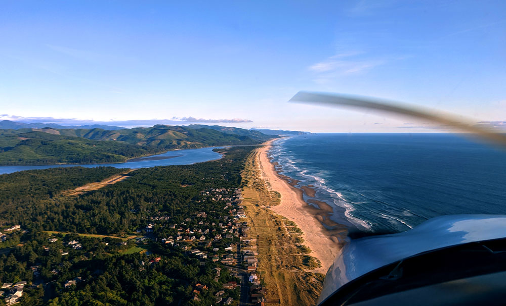
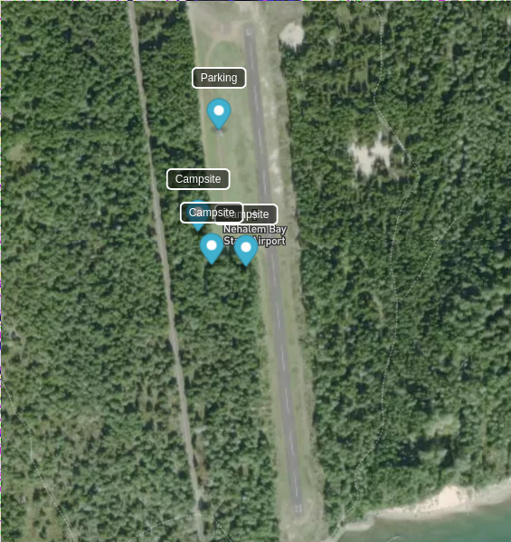
Bonus Airport: 3S7 - Nehalem Bay State / Manzanita
- Elevation: 30ft
- Runway length: 2,350ft
Finally, as a bonus option to consider, Nehalem Bay is in northern Oregon, but well worth the trip down from Washington. Located just outside the town of Manzanita, Nehalem Bay is a state park that sits along the ocean coast down the Nehalem Spit. The airport itself is a half mile inland, but the exchange for not being immediately on the beach is the quiet camping location inside the airport as opposed to the much busier RV camping areas nearer to the beach.
Sitting at sea level, the paved 2,350ft runway poses few difficulties operating from, especially since the south end abuts Nehalem Bay meaning no obstacles to clear. However, being on the coast means frequent marine layers that prevent morning departures. Plan accordingly, even when the forecast calls for sunny weather.
On the west side of the runway are a handful of campsites nestled in the trees for pilots. These sites carry a $11/night fee for camping on the field as of this writing. The beach is a short half mile walk due west. A paved bike/walking trail runs around the airport as well. This is accessible from the south end of the runway or to the north along the main road.
Aside from the beach and camping, the town of Manzanita is 1.5 miles from the airport. This is walkable, but folding bikes are ideal. Within town many options for food, drinks, and shopping exist. Too many to list here, but a personal favorite being Marzano’s Pizza Pie (protip: be in line at 4pm when they open for the evening).
For more info and a detailed map of the airport see Nehalem Bay State on Pirep.
Shameless Plug
The information on this page came from Pirep, a collaborative database of all public, private, and unmapped airports in the US that all pilots can contribute to, no registration required. Do you have information about other airports in Washington? Or even just local knowledge on your home field? If so, you can help out other pilots learn of new places to fly by taking a few minutes to document it on Pirep.io.